What is the June Rise?
Every spring, rivers in the arid mountain west rise as snows melt. Some years there is abundant snow and rivers flow high enough in the spring or early summer to clean and refresh the river. In other years with limited snowfall in the mountains during the winters, spring flows may be greatly diminished and many streams will not have the flows needed to remove algae and vegetation detrimental to the river. In North America, peak snowmelt-driven flows are usually in June — thus the term “June Rise” — but timing can range from late April into July, depending on the weather. On the Cache la Poudre; the June Rise occurs most often in June, though there is some evidence that increasingly warmer air temperatures may ultimately make a “May Rise” more common (Clow, 2010). After the peak flow has past, water levels will drop, sometimes precipitately. If the scouring energy of the June Rise peak is missing or greatly reduced, the river will remain lazy and sluggish for another year, making it even more difficult to clean out when and if high flows come again.
Why is the June Rise Important?
Protecting flows all year long is critical, but there are three main reasons why it is especially important to protect those peak June Rise flows. We know these reasons mostly, and unfortunately, from situations where rivers have been dammed, or from situations where so much water has been removed from rivers that the June Rise either no longer takes place or is just a ghost of its former self. Reasons to protect the June Rise cover the bases of ecology, recreation, and politics:
Ecological Importance
Ecologically, the magnitude, frequency, duration and timing of small peaks and large peaks (floods) play important roles in river health both structurally and biologically. Peak flow benefits have been widely documented in the scientific literature and many are given in Table 1.
| Table 1. Known beneficial effects of peak flows in rivers (see reference list): | |
| Small Peak Flows | Large Peak Flows (floods) |
|---|---|
| Stimulate spawning in fish | All the things that small peaks provide, plus:: |
| Flush out poor water quality | Scour the channel by mobilizing coarse sediment, creating “new” habitat areas to colonize such as point bars, and removing macrophytes and algae from river substrate |
| Mobilize and sort gravel and cobble making the riverbed heterogeneous, supporting more invertebrates (fish food) | Trigger growth bursts among many community members |
| Trigger fish migrations | Clean silt from gravel allowing oxygen to penetrate to life forms that live below the streambed |
| Germinate riparian plant seeds | Deposit silt, nutrients, eggs and seeds in the floodplain nursery habitat |
| Inundate wetland habitats, providing places for waterfowl and amphibians | Recharge soil moisture levels in the banks, sustaining flows during the low flow period |
| Restore “normal” water quality by flushing natural waste products and man-made pollution | Purge many invasive plant and animal species |
| Helps remove vegetation that encroaches into the channel; keeps channel from narrowing through time | |
| Create whole new habitat types such as backwaters and side-channels | |
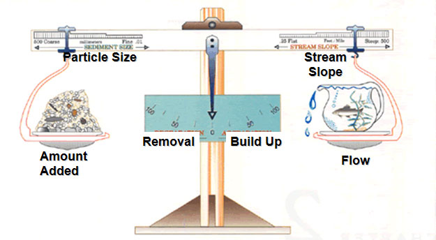
There is a somewhat famous figure that illustrates what happens to a river when the flow regime changes (Figure 1).

In the case of NISP/Glade Reservoir, sediment particle size, the amount of sediment added to the river, and the slope of the river will not change appreciably, but the river’s peak flows will decrease significantly. When flows decrease, the river’s scouring energy declines and sediment will build up in the channel (needle in Figure 1 swings to the right.) When sediment builds up, much of the food base for fish gets smothered and floods will rise more easily out of the riverbanks with catastrophic effects.
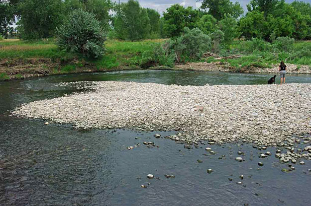
As one example of the cleansing power of high flows, in June of 2010, the Poudre River peaked at 4670 cubic feet per second (cfs) in downtown Fort Collins. This flow was sufficient to mobilize and scour gravel and large cobble, refreshing gravel bars, which create new habitat, and removing almost all the unsightly algae in the river. Figure 2 shows one newly cleaned bar near the Drake Wastewater Treatment Plant.

Recreational Importance
It should also be clear that both instream and streamside recreation are strongly affected by peak flows. In the short run, kayaking, rafting, and canoeing all benefit from those exciting peak flows (up to a safety point, of course). Further, swimming, or just water-contact sports in general, benefit from the uncontaminated fresh water influence on water quality. But it is important to think long term as well. If the river and riparian zone’s ’s health declines due to a decrease in the magnitude, frequency or duration of peak flows, habitat for fish and other aquatic-dependent species (birds, etc.) are negatively affected.

One example says it all. It has been estimated that if NISP/Glade were constructed, a kayak park in Fort Collins would have the number of days of suitable (read fun!) flow reduced from around 70 to 30 per year on average, and the possibility of holding a regional competition with excellent peak flows would likely be eliminated completely.
Institutional Importance
Finally, we would be remiss if we did not tell the story of how the elimination of peak flows in rivers like the Poudre along the Northern Front Range have already destroyed habitat for endangered cranes, plover, and sturgeon in the Platte River through Nebraska and further downstream. Briefly, the reduction in peak flows (and some increase in low flows due to transbasin water transfers from the West Slope) have caused the once “mile wide and inch deep” Platte River — that the Poudre flows into – to shrink drastically in width and become clogged with vegetation. The cranes are wary birds and like to be able to see long distances watching for predators from their roosting habitat on sandbars in the river. With vegetative encroachment, they can no longer see far enough, so they don’t roost well and their population has plummeted. Flow-dependent habitat for the plover and sturgeon, too, has declined tremendously. If we continue to “flatline” our rivers by eliminating the peak flows, these existing problems will expand upstream into our region. Huge amounts of money have been expended, and years devoted, negotiating between Wyoming, Colorado, Nebraska, and the Federal Government over these issues which NISP would just make worse.
How would NISP/Glade affect the Cache la Poudre’s June Rise?
The answer is simple. NISP/Glade is built expressly to remove the Poudre’s peak flows. That’s the only way it can work given NISP’s low priority under Colorado water law. The proposed project would not be capable of completely eliminating the very largest flows (though it would if the potential subscribers could afford it!) but the project would make almost every year a dry year as far as the river is concerned, and peak flows would come along far less frequently and last fewer days when and if they do come. If this project were built, it would be bad news for the Poudre!
Please see an excellent video about the Poudre’s flow regime and the importance of the June Rise here. The PowerPoint slides that accompany that video are here.
Our Position on the June Rise
SaveThePoudre is adamantly opposed to removing the Poudre’s June Rise. It is our intent to educate the public about the benefits of the river rejuvenation process. To that end, every year we sponsor a “June Rise Contest” where we encourage people to guess either the magnitude or the date/time of when the highest flows will occur at the Poudre’s canyon mouth flow gage. We even supply helpful hints about past peak flows and forecasts for the coming season.
Check out some photos from the prize ceremony. Maybe you can win next year!
| References | |
| 1. | Bunn, S.E., and A.H. Arthington. 2002. Basic Principles and Ecological Consequences of Altered Flow Regimes for Aquatic Biodiversity. Environmental Management, 30(4):492−507. |
| 2. | City of Fort Collins. 2008. Characterizing the Cache La Poudre River: Past, Present, and Future. A summary of key findings by the Poudre Technical Advisory Group. 13 pp. Available on the Internet at http://www.fcgov.com/nispreview/pdf/white_paper.pdf |
| 3. | Clow, D.W. 2010. Changes in the Timing of Snowmelt and Streamflow in Colorado: A Response to Recent Warming. Journal of Climate, 23(9):2293-2306. |
| 4. | Chorley, R.J., Schumm, S.A. and Sugden, D.E. 1984. Geomorphology. Methuen and Co. Ltd., New York. |
| 5. | King, J., Brown, C., and Sabet, H. 2003. A Scenario-based Holistic Approach to Environmental Flow Assessments for Rivers. River Research and Applications, 19: 619-639. |
| 6. | Poff, N.L., J.D. Allan, M.B. Bain, J.R. Karr, K.L. Prestegaard, B.D. Richter, R.E. Sparks, and J.C. Stromberg, 1997. The Natural Flow Regime − A Paradigm for Conservation and Restoration of River Ecosystems. BioScience, 47:769−784. |
| 7. | Richter B.D., R. Mathews, D.L. Harrison, and R. Wigington, 2003. Ecologically Sustainable Water Management: Managing River Flows for Ecological Integrity. Ecological Applications, 13(1):206–224. |
| 8. | Richter, B.D., A.T. Warner, J.L. Meyer and K. Lutz. 2006. A Collaborative and Adaptive Process for Developing Environmental Flow Recommendations. River Res. Applic., 22:297–318. |
